

Recent approaches to the preservation of cultural heritage are evolving towards a holistic understanding of conservation that encompasses not only the physical continuity of the heritage but also the documentation of the processes through which this heritage was produced, transformed, and acquired meaning [1]. This transformation, particularly with the development of digital technologies, redefined how heritage is represented [2]. The practices of measurement, recording, and archiving shifted from static inventory models to dynamic, updatable data environments [3]. Digital preservation methods provide a research infrastructure that not only documents the current state of cultural heritage but also makes traces of the past visible again, brings together data from different time periods, reveals its memories, and makes spatial continuity analysable [4]. Furthermore, Fai and Rafeiro [5] demonstrated that digital heritage models not only produce representations but can also be used as analytical tools in decision-making processes.
Cultural heritage is often physically restored, but this process is often limited to the building's physical integrity. This is referred to as reconstruction in the existing literature [6, 7]. However, the historical disruptions, losses and transformations that historical buildings have undergone can only be comprehensively appreciated to the extent that they can be reproduced in a digital environment [8]. Therefore, conservation practice today should include a digital reconstruction process that proceeds in parallel with physical reconstruction [9]. The ability to superimpose data from different periods using digital models enables the reading of not only a single moment in time but also its temporal layers [10]. Georgoula et al. [11] demonstrated that superimposing temporal layers can read the morphological evolution of structures in a digital environment. This approach redefines heritage conservation not so much in terms of the object itself, but rather in terms of documenting the structure's temporal continuity and transformation.
Documentation and inventory creation processes need to be reinterpreted in light of the changes technology has undergone in recent times. Traditional inventory methods are unable to keep pace with the speed and changes in contemporary conservation approaches [12]. At this point, digital preservation methods, which advance in parallel with the development of technology and capabilities, clearly facilitate the digitisation, access, recording, updating, dissemination, and storage of cultural heritage assets [13–16]. Champion and Rahaman [17] emphasise that multi-layered data models, at the intersection of digital heritage and memory studies, enable the reinterpretation of the past. This model is a powerful tool not only for conservation processes but also for the re-establishment of cultural memory in the digital environment.
In recent years, the preservation of cultural heritage is not only viewed as the documentation of values from the past but is also addressed within the framework of the “smart heritage” approach, which supports decision-making processes for the future [18, 19]. The smart heritage approach aims to monitor cultural heritage sites continuously, identify risks in advance, and develop data-driven management decisions by integrating digital technologies, big data, artificial intelligence, and geographic information systems. Thus, digital models are evolving from outputs produced for documentation purposes into dynamic decision-support systems that support conservation, planning, disaster management, and sustainable heritage governance [20, 21]. Similarly, the “digital twin” approach, which has emerged in recent years, has created new research areas for tracking cultural heritage sites throughout their life cycles [22]. However, a significant portion of current studies treat digital twins as synchronous models focused on tracking the current physical state, while the question of how to integrate historical layers from past periods into the same model remains largely unresolved. For this reason, simply documenting existing structures is not sufficient in post-disaster reconstruction processes. The development of digital tracking inventory that reveal the historical continuity of buildings is required.
Digital documentation approaches based on the spatial alignment of temporally layered data have the potential to yield tangible, comparable results for cultural heritage buildings that bear the traces of sudden disruptions such as war, disasters, and fires [23]. The Sarajevo City Hall building presents a unique research area offering multi-layered data due to the destruction, fire and reconstruction processes [24]. The fire disasters that occur almost every year across different geographical areas and can cause irreversible destruction of cultural heritage are discussed, using this building as a specific example. A three-dimensional (3D) digital model of the building was created. In addition, visual and spatial data from different periods were superimposed using a TLSA method and made reinterpretable in a digital environment. However, no study was found in the existing literature that compares data from different periods of the building within a common spatial reference system, digitally documents its current condition with a high degree of accuracy, and assesses its life cycle in a holistic manner. This situation points to a significant research gap, particularly with regard to the systematic tracking of pre- and post-disaster changes and the data-driven evaluation of reconstruction processes.
This study aims to address this gap by proposing a multi-layered digital memory model that integrates a photogrammetric model-based digital inventory with the TLSA method. The main contribution of the study is that it provides an interdisciplinary framework within which visual and spatial data from different periods can be linked within the same reference system, thereby enabling the analytical assessment of post-disaster cultural heritage reconstruction processes. Aiming to fill a gap in the literature, the study emphasises the importance of tracking post-fire disaster processes in cultural heritage sites and of pre- and post-disaster digital documentation. In this respect, the proposed approach goes beyond the creation of a static archive through digital documentation, offering a practical decision-support infrastructure for conservation planning, the evaluation of reconstruction decisions, and sustainable heritage management. Consequently, by ensuring that the changes and transformations a structure undergoes throughout its lifespan are documented and tracked via digital platforms, guidance is provided for the creation of a more effective, sustainable and scalable environment to support future conservation and intervention processes.
The development of digital approaches to the preservation of cultural heritage has necessitated a reconsideration of the concept of memory. Today, memory is viewed not only as an archive where information about the past is stored, but also as a dynamic information system that is constantly reproduced and reinterpreted across different times [25,26,27]. For this reason, the contemporary understanding of preservation considers the documentation of the changes, transformations, and interventions the structure has undergone over time to be an integral part of cultural heritage, alongside the preservation of the structure's physical existence. The concept of memory, as well, is approached not merely as an individual process of recollection but as a social and cultural structure in which societies' relationship with the past is constantly reproduced. Assmann [25] defines cultural memory as a shared knowledge system that enables societies to sustain their identities; Pierre Nora [26], meanwhile, states that memory exists not only in physical spaces but also in the meanings attributed to those spaces and in social practices. Similarly, Erll [27] points out that memory is not a static record-keeping system but a dynamic process that is reinterpreted, updated, and reproduced across different periods.
Although the concept of digital memory emerged as a result of the widespread adoption of digital technologies, it has become clear over time that digital environments are not simply storage spaces [28–30]. Today, digital platforms have become interactive information environments where information from the past is recontextualised, data from different periods is brought together, and users can attach new meanings to this data. In other words, digital environments are no longer systems that store the past; they are memory environments that reproduce and interpret the past [31, 32]. At this point, it is necessary to distinguish between the concepts of digitisation, digital documentation, and digital memory, which are often used interchangeably in the literature. While digitisation refers to the process of transferring analogue data to a digital environment, digital documentation involves recording the physical condition of a cultural heritage site at a specific point using methods such as photogrammetry, laser scanning, or similar techniques [14, 33]. In contrast, digital memory refers not to the storage of data, but to a dynamic structure of knowledge in which information from different times is linked, interpreted, and continuously developed [17, 28, 29]. Consequently, digital memory is not a natural outcome of digital documentation; rather, it is a new layer of knowledge formed by establishing temporal, spatial, and semantic relationships among data. For a digital memory to emerge, documents from the past, archival photographs, historical drawings, and data produced during different periods must be linked within a common reference system [30, 31].
Technologies such as photogrammetry, laser scanning, Building Information Modelling (BIM), and digital twins, which are used for the digital documentation of cultural heritage, have led to significant advances in conservation efforts recently [34, 35]. Although current methods for the digital documentation of cultural heritage can produce high-accuracy geometric models, they have limitations when it comes to establishing analytical relationships between spatial data from different periods. Photogrammetry, laser scanning, HBIM, and digital twin approaches primarily represent the physical condition of a structure at a specific point in time; historical photographs, on the other hand, are often considered merely archival in nature [36]. Similarly, while Geographic Information Systems (GIS) and historical image matching studies enable the integration of spatial data within a common coordinate system, the majority of these focus on spatial accuracy at the urban scale; they do not offer a holistic approach to the visual, spatial, and temporal interpretation of architectural-scale historical transformations [37, 38]. TLSA approach proposed in this study was developed as a relational analytical framework aimed at addressing this gap (Table 1). The uniqueness of TLSA lies not only in the use of historical photographs as visual documents, but also in the alignment of visual and spatial data from different periods within a common reference system—based on perspective, scale, and geometric continuity—and in making the changes between these layers analytically interpretable.
| Method | Documentation | Spatial Analysis | Temporal Comparison | Multi-layer Memory | Decision Support |
|---|---|---|---|---|---|
| Traditional Archive | ✓ | ✗ | Limited | ✗ | ✗ |
| Photogrammetry | ✓ | ✓ | ✗ | ✗ | Limited |
| 2D/3D GIS | ✓ | ✓ | Partial | ✗ | ✓ |
| HBIM | ✓ | ✓ | Partial | ✗ | ✓ |
| Digital Twin | ✓ | ✓ | Limited | Partial | ✓ |
| TLSA (This study) | ✓ | ✓ | ✓ | ✓ | ✓ |
Unlike conventional photogrammetric documentation, GIS-based temporal mapping, or digital twin applications, TLSA does not replace these approaches; instead, it establishes a relational analytical framework that spatially aligns historical visual evidence with contemporary metric documentation to generate a multi-layer digital memory.
Sarajevo, due to its geopolitical location, is a strategic crossroads between Central Europe and the Balkans. This location has played a decisive role in shaping the city's multi-layered cultural structure throughout history. Sarajevo City Hall (Vijećnica) plays an important role in the city's historical and spatial continuity. The building is located on the banks of the Miljacka River, which divides the city in two, and is close to Mustaj Paşa Square, a focal point of the historical urban landscape (Figure 1).
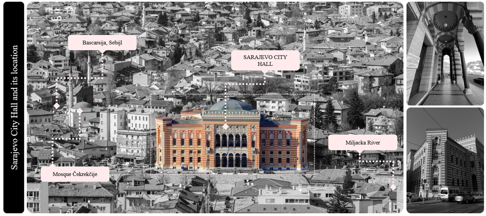
Construction of the building began in 1892, and it was opened as a municipal building on 20 April 1896. Designed as the most representative public building of the Austro-Hungarian administration in Sarajevo, it served as the city's administrative centre for many years [39]. The building and its facade, which aimed to create a symbolic architectural language between the Ottoman past and the new administration, play a central role in discussions about Sarajevo's architectural identity [40, 41].
The building was reused after the Second World War as the National and University Library of Bosnia and Herzegovina, becoming a repository of cultural memory. However, it was targeted during the Siege of Sarajevo between 25 July and 2 August 1992, suffering extensive damage and losing its collection of approximately 1.5 million volumes [19, 42]. This event was not only a physical destruction but also an intervention aimed at the systematic elimination of cultural memory, which was widely discussed in international literature [43]. After the fire, the building underwent a long-term reconstruction process and reopened in 2014, regaining its public and cultural functions [40].
This study examines Sarajevo City Hall, a landmark representing the city's historical, administrative and spatial development. The study's methodological framework was divided into two stages. The first stage is documentation, and the second is temporal layered spatial alignment (TLSA). The first stage involves the systematic collection and organisation of physical, visual and historical data relating to the research area in accordance with the Documentation Components (DC). The second stage, TLSA, involves inter-layer visual matching and alignment processes that enable the comparative analysis of data from different periods. Both stages consist of defined, sequential, and comprehensive sub-steps. This ensures analytical depth, traceability, and method repeatability (Figure 2).
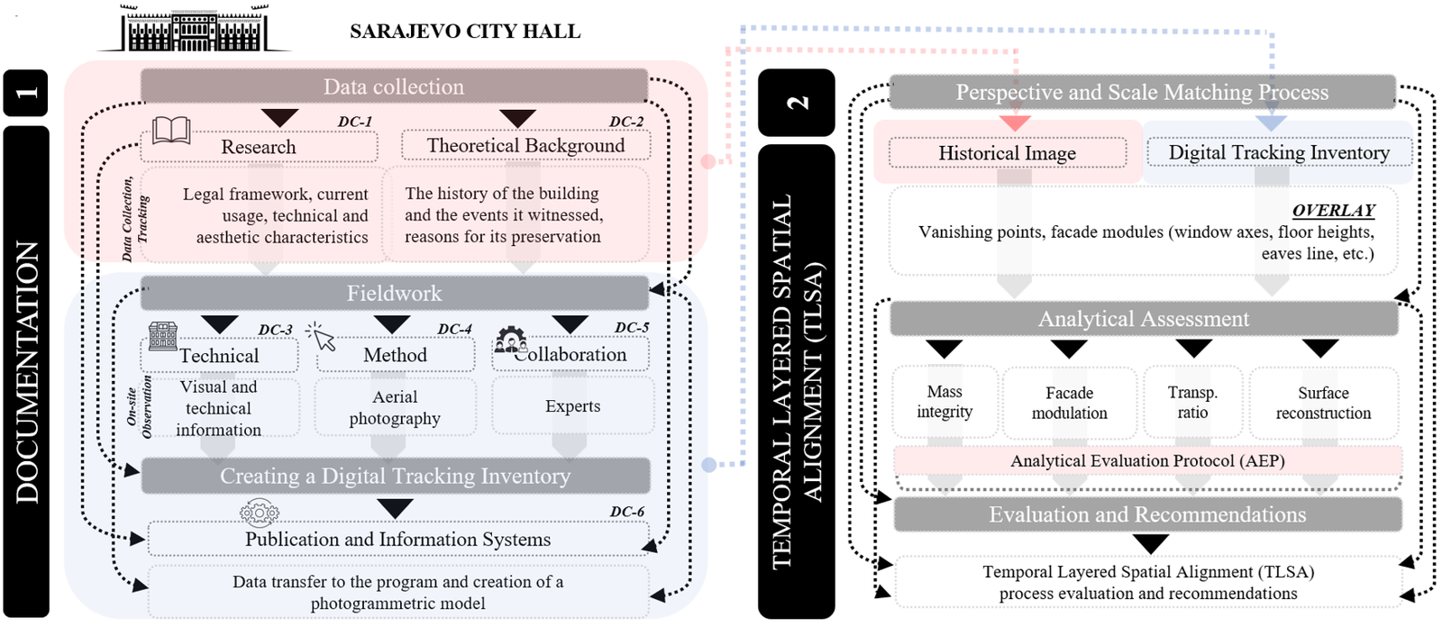
The documentation stage consists of three fundamental steps: data collection, fieldwork, and the creation of a digital tracking inventory. This stage was designed utilising documentation components (DC). The DC consist of seven elements: research (DC1), theoretical framework (DC2), technical aspects (3), appropriate method selection (DC4), collaboration (DC5), publication and information systems (DC6), and financial support (DC7) [44,45,46]. Research concerns characteristics such as the legal framework, history of the structure, its use, and its technical and aesthetic features. Theoretical framework also relates to the history of the building and important facts and policies that allow for its preservation. Technical is the step where conclusions are drawn and rationalised based on the building itself being the primary source of technical knowledge. Appropriate Method Selection involves deciding on the technique to be applied in Cultural Heritage Documentation. Collaboration is a component related to the joint work of various disciplines concerning the structure. Publication and Information Systems is the stage concerning the final products of documentation. It refers to the methods for storing, accessing and using data. Financial Support covers the financial aspects required to achieve all of the above. However, as no financial support was required during the study, the financial support component was not included in these stages. The documentation stage has a holistic structure that aims to produce data on the space under investigation in a systematic, consistent, and analysable framework. Each step forms the theoretical and technical basis for the next stage, TLSA.
The second stage of the study, Temporal Layered Spatial Alignment (TLSA), aims to comparatively analyse the spatial and morphological conditions of structures across different periods and to measure temporal changes. This stage comprises three steps: Perspective and Scale Matching Process, Analytical Assessment, and the presentation of assessments and recommendations for the TLSA process.
| Parameter | Evaluation Criteria | Score |
|---|---|---|
| Massive Integrity | The building's overall volume, number of floors, roof shape, and silhouette are compared with the historical appearance. | x/5 |
| Facade Modulation | Window axes, floor lines, column spacing, and the rhythm of the facade are examined. | x/5 |
| Opening Ratio | The number, size, and ratio of solid to void areas in door and window openings are evaluated. | x/5 |
| Surface Reconstruction | Facade materials, decorative elements, surface characteristics, and continuity of details are examined. | x/5 |
| 1=very different, 2=different, 3=partially similar, 4=largely similar, 5=almost the same | ||
The documentation of historical buildings, containing a wealth of culturally and socially significant data, is crucial for conservation practices. In this study, a digital 3D photogrammetric model was created for the Sarajevo City Hall, one of the architectural examples that best reflects Bosnian architectural culture and material usage. In the photogrammetric modelling process, photographs that can be matched to each other are required for the software's depth perception algorithm. This enables the software to create a model by aligning the photographs.
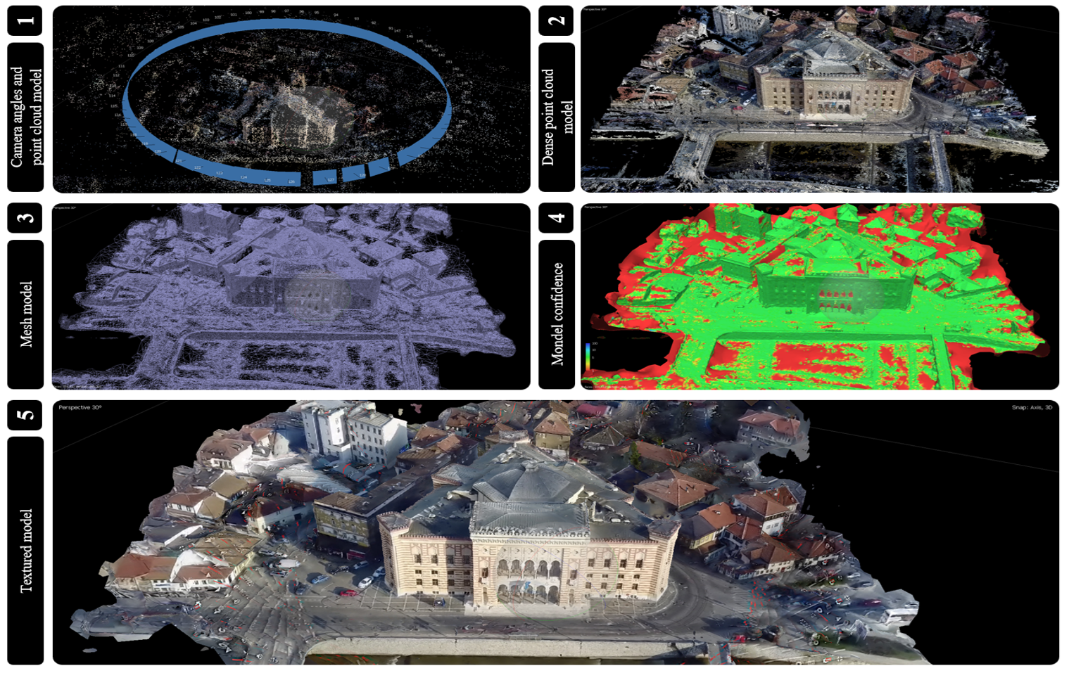
Photographs were obtained during fieldwork conducted in 2018 and 2023 for the Sarajevo City Hall. The Metashape program was used to create the photogrammetric model [52]. The first stage of the model creation process is adding the photographs to the program. The 57 photographs were imported into Metashape, and the alignment process was initiated. At the end of the alignment process, the program identified and aligned all the photographs, resulting in a point cloud with the aligned camera angles. The photographs identified as a point cloud are prepared for the creation of a dense point cloud. The dense point cloud model of the building was generated using the automatically defined ‘build dense cloud’ command in Metashape. The building's dense point cloud contains 9,174,330 points. Before creating a mesh model from a dense point cloud, unnecessary points can be removed using the quick selection command. Data that is not required, such as that captured by the camera angles, can also be identified and modelled by the program. Therefore, unnecessary elements in the process, such as different structures, trees, cars, roads, etc., that are far from the building, should be removed from the model. After cleaning, the mesh creation can be completed more quickly and efficiently. The mesh model is created by the program, which connects the points in the dense point cloud. The duration of this process increases with the number of points. Following mesh generation, a confidence model can also be produced to assess the reliability of the reconstructed geometry, enabling the identification of areas with high and low confidence. Consequently, as mentioned, cleaning unnecessary data in the previous stage facilitates the process (Figure 3).
The model was formed from 931,512.00 mesh points. After the meshing process, the textures visible in the photograph can be defined on the model. Using the software's automatic texture detection feature, the textures from the photographs are mapped onto the meshes. After completing the mesh model of Sarajevo City Hall, the textures from the photographs were applied to the model, creating a representation of its current state.
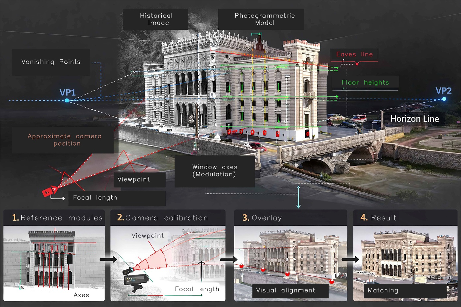
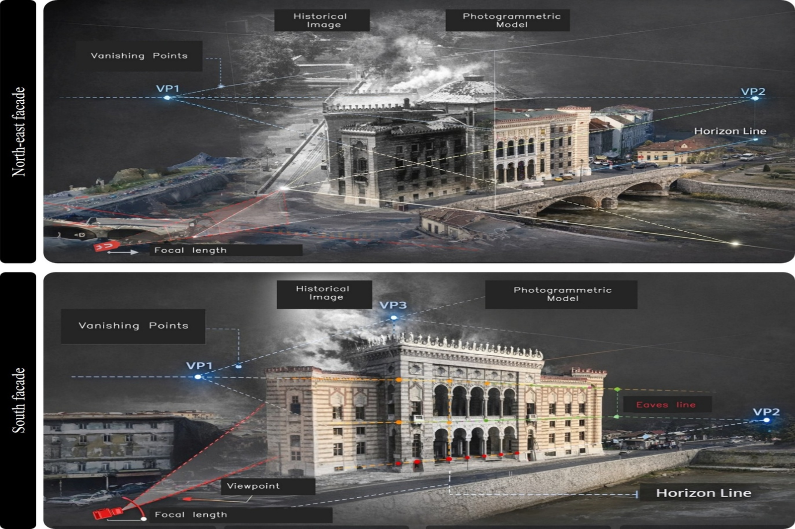
The digital photogrammetric model of Sarajevo City Hall was compared with pre-war historical images of the building using the TLSA approach (Figure 4).
The images, with perspective and scale matched, were superimposed using a semi-transparent layering method to analyse the morphological relationships between the building's pre-war and reconstructed states. This comparison reveals the extent to which the original massing and facade design were preserved during the post-demolition reconstruction process, enabling the visual and measurable assessment of continuity, intervention, and reproduction areas (Figure 5). Thus, a comparative framework based not only on visual relationships but also on analytical and morphological foundations was established between the past and the present.
The analytical assessment of aligned images with perspective and scale matching aims to reveal the morphological relationship established by the building, reconstructed after being destroyed in the war, and its historical references. In this context, the building's adherence to its original form during reconstruction was examined in terms of formal continuity and the levels of intervention. The comparative analysis was conducted in accordance with morphological parameters defined at the mass and facade scales, and the findings were explained Table 3.
The assessment conducted within the framework of the AEP reveals that the building's original massing and façade composition were largely preserved during the post-war reconstruction process. The building's overall morphological characteristics, which define its urban silhouette and identity, were largely preserved during the reconstruction process; however, controlled alterations were implemented in the micro-scale architectural elements that engage directly with the user. In particular, the adjustments to the arrangement of openings and the limited interventions in façade modulation observed on the ground floor should not be regarded merely as architectural changes. They can also be considered as a result of the building's adaptation to current functional requirements and safety conditions. This situation indicates that the building's relationship with the public space was partially redefined compared to the pre-war period.
Similarly, the simplification observed in the decorative elements should not be regarded merely as a physical loss. It reflects the balance achieved between the limited availability of original materials and craftsmanship during the building's reconstruction process and the interpretative approach of contemporary conservation principles. Nevertheless, the preservation of the main massing, the rhythm of the façade and the fundamental architectural character ensures the continuity of the building's symbolic identity within the city's collective memory. In this context, TLSA analyses reveal which parts of the structure have changed and the scale of these changes. They also show the architectural components on which the change is based and the effect of these interventions on cultural memory and urban continuity. Therefore, the morphological differences identified demonstrate that post-war reconstruction was not just a physical reconstruction process but also reflected a multi-layered conservation approach aimed at maintaining cultural identity, public memory, and urban continuity.
| Parameter | Explanations | Score |
|---|---|---|
| Mass Integrity | Examination of the superimposed images reveals that, despite being destroyed during the war and subsequently reconstructed, the main mass organisation was largely rebuilt in reference to its original form. The main prismatic volume, corner accents, floor silhouette, and eaves level are highly consistent between the historical image and the current photogrammetric model. This indicates that the restoration decisions during the reconstruction process aimed for a faithful reproduction at the mass scale. Therefore, mass integrity was achieved through formal continuity rather than physical continuity. | 5/5 |
| Facade Modulation | Analysis based on window axes, floor heights, and horizontal line references determined that the vertical and horizontal modulation system was largely preserved. Floor lines and axis continuity were consistent with historical references. However, partial interventions and simplifications of details were observed in some opening arrangements, particularly at ground level. Although the overall rhythm was preserved, variations in proportions and details at the micro level indicate a low to medium level of deterioration. | 4/5 |
| Opening Ratio | In a comparison based on the solid-void ratio, it was observed that the openness ratios of the upper floors largely matched the historical appearance. In contrast, some openings on the ground floor were found to be closed, reduced, or rearranged. This indicates a local decrease in facade permeability. However, this change is not on a scale that would disrupt the holistic character of the facade composition. | 4/5 |
| Surface Reconstruction | Due to the building's reconstruction, the surface texture does not maintain the continuity of the original material. However, the historical facade character was restored in terms of form. The stone cladding system, horizontal band arrangement, and eaves details were reconstructed in accordance with historical references. In contrast, the ornamental elements were simplified. This indicates that the focus was on visual and morphological continuity rather than physical authenticity. | 3/5 |
| 1=very different, 2=different, 3=partially similar, 4=largely similar, 5=almost the same | ||
The absence of a pre-war digital model of the Sarajevo City Hall building prolonged the post-war restoration process. The use of digital models to track decision-making and implementation will accelerate restoration and conservation processes. The processes of archiving and recording, which play an important role in the preservation of cultural heritage, also need to be reinterpreted in light of recent technological changes. The virtual environment provided by digitalisation is generating new perspectives on the traditional concept of ‘archive/inventory’. Digital inventories created by users interested in traditional knowledge, and supported by certain civil society organisations or governments, inevitably constitute a user-community-based, participatory space.
The Sarajevo City Hall building was also digitised using photogrammetric modelling techniques, which have become increasingly common with technological advances, to create a three-dimensional digital tracking inventory of the building. Photogrammetric models can accelerate the design, implementation, and preservation processes for architects, engineers, and designers. A detailed digital model of the building provides the flexibility to work and make design changes in real time. Used in various simulation and training scenarios, it helps create a realistic environment, for example, in fire safety training or emergency scenarios.
The integration of the photogrammetric model into the TLSA process provides a comparative environment where past spatial traces can also be reproduced. This approach shifts the authenticity-reproduction debate, frequently encountered in reconstruction processes, to a data-driven foundation. It enables the evaluation of intervention decisions based on objective criteria. Furthermore, this method provides a framework for comparing pre- and post-disaster conditions, thereby offering a new perspective for risk management and preservation planning.
The advantages provided by the photogrammetric model of the Sarajevo City Hall created within the scope of the study are summarised below:
The multi-layered digital memory model should be considered a dynamic decision-support system in which data is stored, its temporal evolution can be read, different intervention scenarios can be tested, and the continuity of cultural heritage can be tracked. The layers created with TLSA combine the destruction, fire, and reconstruction processes the building experienced in a single spatial plane, producing a spatial counterpart of collective memory. This approach does not entirely eliminate the authenticity–reproduction dilemma that is frequently debated in reconstruction processes; however, it contributes to the discussion of intervention decisions within a more transparent, traceable and data-driven framework.
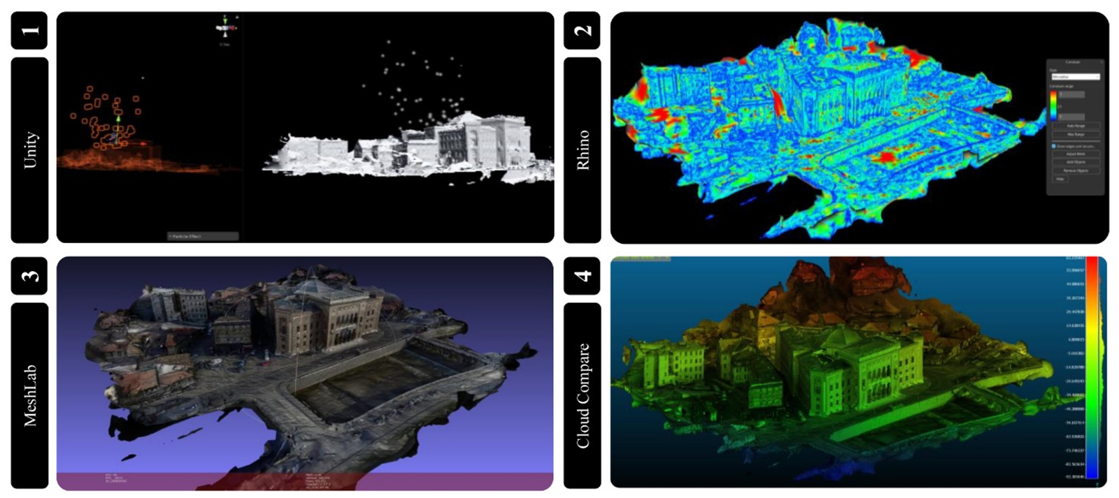
The photogrammetric model created during the development of the TLSA approach provides a comprehensive data infrastructure for documenting cultural heritage and passing it on to future generations. One of the model's key advantages is its portability across different software environments, enabling a wide range of analyses to be performed. In this context, the 3D digital model created for Sarajevo City Hall was adapted into a research environment facilitating analytical assessments. By importing the model into the Unity environment, interactive scenarios relating to the building and its surroundings could be created. Particle-based visualisations were developed using point cloud and mesh data. This application offers significant potential for testing future scenarios—such as fire, disaster, or user movement simulations—in a digital environment. Surface curvature analyses conducted in the Rhino enabled the interpretation of the building's geometric characteristics. The analysis results indicate that low curvature values are concentrated on facade surfaces and large planar areas, while high curvature values are concentrated at corner junctions, eaves details, roof slopes, and topographical transition zones. This provides reference data for future analyses of deformation, surface deterioration and material loss. Using MeshLab and the ambient occlusion process, the surface quality and visual clarity of the model were enhanced, and a realistic digital representation of the structure was achieved using high-resolution textures. Elevation analyses performed in the CloudCompare environment enabled a numerical assessment of the model's vertical organisation. The analysis results revealed a total vertical data range of approximately 15.71 m, varying between approximately -9.33 m and +6.37 m. The elevation maps created provided a visualisation of the elevation relationships between the building and the surrounding urban fabric. This established a quantitative data infrastructure that can be utilised for assessments of visibility, accessibility, disaster risk management and the urban skyline (Figure 6). As Figure 6 indicates, the photogrammetric model generated was processed within various software environments, thereby transcending its role as a mere visual representation and being transformed into a multi-purpose analysis platform.
The model created as part of this study closely matches the building's actual dimensions by obtaining data for this building, which had previously suffered a major disaster, such as a fire. A digital model of its current state was created, contributing to intergenerational interaction. When applied at specific intervals to the Sarajevo City Hall, which continues to exist today after many years, this modelling enables the creation of a digital tracking inventory of the building. This will allow communication among the building's layered memories in the past, present, and future. However, the multi-layered approach to digital memory should not be viewed merely as a new documentation technique. The re-representation of cultural heritage in a digital environment also involves an ethical decision-making process. This is because digital memory is not an exact copy of the past; rather, it is a new layer of interpretation constructed on the basis of existing data. The choice of which historical documents to use, which times to represent, and which changes to reference is directly related to the researcher's methodological decisions. For this reason, digital memory should be regarded not as a means of producing an absolute reality but as a dynamic field of knowledge in which different pieces of evidence are transparently linked, can be scrutinised, and can be reinterpreted in light of new data.
The TLSA approach does not aim to produce a single, definitive historical narrative. Instead, it makes the different temporal layers of cultural heritage visible within the same spatial reference system, enabling the simultaneous interpretation of change, continuity, and interventions. The main contribution of the proposed approach is to clarify and open to discussion the data used to make decisions about the reconstruction's accuracy. TLSA is not a method that eliminates the long-standing debates on authenticity and representation in the field of conservation; rather, it provides an analytical framework that contributes to these discussions being conducted in a more transparent and data-driven manner. However, the method's reliability depends on the quality of the historical documents used, the accuracy of the photogrammetric model, and the precision of the alignment between temporal layers. It is therefore important that future studies, involving experts from different user groups and disciplines, test the method's reproducibility, assess its applicability to different types of cultural heritage, and integrate it into decision-support processes alongside technologies such as digital twins, structural health monitoring systems and AI-supported change analysis.
The Sarajevo City Hall clearly demonstrates how sudden disruptions, such as war and fire, cause not only physical losses to cultural heritage but also interrupt its temporal continuity. The photogrammetric model-based digital tracking inventory developed within the scope of this study produced a data infrastructure available for use by different disciplines, analysable and updatable, and capable of documenting the current state of the building with high accuracy. The TLSA method, which aligns visual and spatial data from different periods onto a common reference plane, enabled a comparative interpretation of the building's transformation processes and demonstrated that its reconstruction could be approached as a data-driven evaluation. This approach shifts the preservation of cultural heritage beyond static inventory production, transforming it into a multi-layered digital memory model that tracks the transformations a building experiences throughout its life cycle. The created 3D model enables the pre-testing of potential disaster scenarios, the development of intervention decisions based on objective data, and the handling of protection processes within a sustainable management model. Thus, digital documentation is transformed from a tool that merely records the current situation into an analytical, traceable, and repeatable decision support system that establishes continuity between the past and the future. This approach can also lead to developments such as the below:
The study concludes that the simultaneous implementation of physical and digital reconstruction processes is essential for the preservation of cultural heritage. It emphasises that the digital tracking inventory approach based on periodic data production offers a robust model for sustainable conservation. In this respect, the study proposes an applicable, interdisciplinary, and data-driven conservation method for cultural heritage buildings at risk of disaster. In particular, comprehensive assessments of data from different periods will assist in ensuring that decisions on intervention during conservation and rehabilitation processes following conflicts, natural disasters, and climate-related risks are informed, traceable, and comparable. In this context, the TLSA approach should be regarded as a dynamic information infrastructure supporting the development of policies for future planning, risk management, and sustainable conservation. Consequently, this study redefines digital reconstruction as an analytical, interdisciplinary planning tool that informs decision-making processes concerning the future of cultural heritage.
All authors contributed equally to the conception, development, analysis, and preparation of the manuscript. All authors reviewed and approved the final version of the manuscript.
The authors declare that there are no conflicts of interest associated with this study.
This research received no external funding.
The data supporting the findings of this study are included within the manuscript.
Ethical approval was not required for this study, as the research did not involve human participants, human-derived data, or interventions requiring institutional ethical review. Accordingly, informed consent was not applicable.